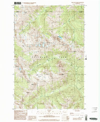
1999 Map of Wellesley Peak
USGS Topo · Published 2003About this map
Olympic National Park defines the high-altitude landscape of this Jefferson County interior, centered on the Wellesley Peak and Mount Cameron massifs. The terrain is characterized by massive ice and water features, including the Cameron Glaciers and the headwaters of the Lillian River, Gray Wolf River, and Dosewallips River. High passes like Grand Pass and Hayden Pass link the deep drainage basins, while extensive subalpine clearings such as Dose Meadow and Thousand Acre Meadow suggest the seasonal migration patterns of wildlife and early backcountry travelers. Backcountry shelters and established sites such as Bear Camp and Camp Marion dot the trails, reflecting the preservation of this wilderness for recreation. The presence of Sentinels Sister and Mount Fromme further illustrates the complex geology of the Olympic interior before the turn of the millennium.
Find a feature on this map
37 named features on this map. Tap any name to fly to it.
Don’t see what you’re looking for? This feature index may not catch every label — zoom into the map to look around manually.
Map Details
Editions of this 1999 Wellesley Peak Map
This is the sole edition of this map. No revisions or reprints were ever made.
Other maps of this area

1938 · Mt Constance
USGS Topo · 1:125,000

1944 · Mt. Angeles
USGS Topo · 1:62,500

1946 · Mt. Angeles
USGS Topo · 1:62,500

1946 · Tyler Peak
USGS Topo · 1:62,500

1947 · The Brothers
USGS Topo · 1:62,500

1947 · Mt. Steel
USGS Topo · 1:62,500

1948 · Tyler Peak
USGS Topo · 1:62,500

1950 · The Brothers
USGS Topo · 1:62,500

1950 · Mt. Steel
USGS Topo · 1:62,500

1958 · Seattle
USGS Topo · 1:250,000