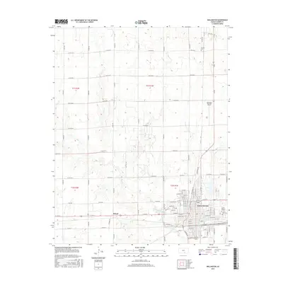
2015 Map of Wellington
USGS Topo · Published 2015About this map
Wellington serves as the primary hub of this south-central Kansas landscape, where the grid of city streets meets the expansive agricultural section lines of Sumner County. The 2015 survey reveals the town's modern footprint, including the Wellington Municipal Airport and residential developments extending toward Sumner Memorial Gardens. Outside the city limits, the terrain is defined by the drainage of Slate Creek and several smaller tributaries like Spring Cr and Oak Cr. The map preserves the location of historic rural sites such as Fairview Cem to the north and the settlement of Roland situated along the western approach to the city. This record shows how the local infrastructure, from Hillside St to the numerous numbered avenues, has integrated with the natural watercourses that define the county's topography.
Find a feature on this map
90 named features on this map. Tap any name to fly to it.
Don’t see what you’re looking for? This feature index may not catch every label — zoom into the map to look around manually.
Map Details
Editions of this 2015 Wellington Map
This is the sole edition of this map. No revisions or reprints were ever made.
Other maps of this area

1889 · Caldwell
USGS Topo · 1:125,000

1890 · Wellington
USGS Topo · 1:125,000

1893 · Caldwell
USGS Topo · 1:125,000

1897 · Caldwell
USGS Topo · 1:125,000

1955 · Belle Plaine
USGS Topo · 1:24,000
1955 · Zyba
USGS Topo · 1:24,000

1955 · Wichita
USGS Topo · 1:250,000

1958 · Wichita
USGS Topo · 1:250,000

1964 · South Haven NE
USGS Topo · 1:24,000

1964 · Dalton
USGS Topo · 1:24,000