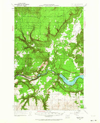
1953 Map of Wellpinit
USGS Topo · Published 1964About this map
Spokane Indian Reservation lands dominate this mid-century survey, centered on the settlement of Wellpinit. The landscape is defined by the deep incision of the Spokane River and Long Lake along the southern border, where the boundary between Stevens and Lincoln counties follows the water's edge. To the east, the Chamokane Prairie offers a flatter contrast to the complex topography of Rail Canyon, Cork Screw Canyon, and Devils Gap.
Find a feature on this map
25 named features on this map. Tap any name to fly to it.
Don’t see what you’re looking for? This feature index may not catch every label — zoom into the map to look around manually.
Map Details
Editions of this 1953 Wellpinit Map
3 editions found

Other maps of this area

1927 · Chewelah
USGS Topo · 1:125,000

1930 · Chewelah
USGS Topo · 1:125,000

1943 · Medical Lake
USGS Topo · 1:62,500

1944 · Clayton
USGS Topo · 1:62,500

1944 · Wellpinit
USGS Topo · 1:62,500

1945 · Reardan
USGS Topo · 1:62,500

1948 · Hunters
USGS Topo · 1:62,500

1948 · Turtle Lake
USGS Topo · 1:62,500

1950 · Turtle Lake
USGS Topo · 1:62,500

1950 · Hunters
USGS Topo · 1:62,500