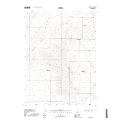
2018 Map of Wells Peak
USGS Topo · Published 2018About this map
Wells Peak dominates this high-altitude landscape in the Windermere Hills of northeastern Nevada. This 2018 survey documents a region defined by its vital water sources, where numerous named springs serve as critical landmarks across the arid terrain. From Wilson Spring and Cricket Spring in the north to Quillet Spring further south, these locations highlight the hydraulic history and land-use patterns of the Great Basin. Small drainages like Town Cr and Rabbit Cr flow through the valleys, following seasonal patterns that have dictated movement through this part of Elko County for generations. The map's detailed grid work and topographic contours provide a clear view of the complex ridges and ravines that characterize the high desert environment east of the town of Wells.
Find a feature on this map
17 named features on this map. Tap any name to fly to it.
Don’t see what you’re looking for? This feature index may not catch every label — zoom into the map to look around manually.
Map Details
Editions of this 2018 Wells Peak Map
This is the sole edition of this map. No revisions or reprints were ever made.
Other maps of this area

1955 · Wells
USGS Topo · 1:250,000

1958 · Wells
USGS Topo · 1:250,000

1961 · Wells
USGS Topo · 1:250,000

1968 · Moor Summit
USGS Topo · 1:24,000

1968 · Holborn
USGS Topo · 1:24,000

1968 · Wells
USGS Topo · 1:24,000

1968 · Melandco
USGS Topo · 1:24,000
1968 · Pequop Summit SW
USGS Topo · 1:24,000

1968 · Wells Peak
USGS Topo · 1:24,000

1968 · Summer Camp
USGS Topo · 1:24,000