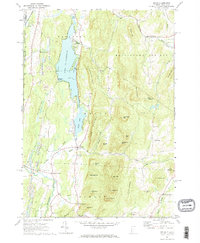
1967 Map of Wells
USGS Topo · Published 1972About this map
Lake St Catherine dominates the valley floor between the steep slopes of Pond Mountain and St Catherine Mtn, serving as a central geographic feature for the surrounding Vermont and New York borderlands. This late-1960s landscape is defined by its industrial and agricultural balance, where extensive Quarries and gravel pits operate alongside small hamlets like South Poultney and Wells. The southern portion of the map follows the winding course of the Mettawee River through Blossoms Corners toward North Pawlet, a region marked by numerous family-named peaks such as Simonds Hill and Cleveland Hill.
Find a feature on this map
64 named features on this map. Tap any name to fly to it.
Don’t see what you’re looking for? This feature index may not catch every label — zoom into the map to look around manually.
Map Details
Editions of this 1967 Wells Map
2 editions found
Other maps of this area

1893 · Fort Ann
USGS Topo · 1:62,500

1893 · Whitehall
USGS Topo · 1:62,500

1894 · Pawlet
USGS Topo · 1:62,500

1895 · Whitehall
USGS Topo · 1:62,500

1895 · Fort Ann
USGS Topo · 1:62,500

1895 · Castleton
USGS Topo · 1:62,500

1897 · Pawlet
USGS Topo · 1:62,500

1897 · Castleton
USGS Topo · 1:62,500

1898 · Whitehall
USGS Topo · 1:62,500

1898 · Fort Ann
USGS Topo · 1:62,500