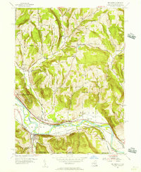
1954 Map of Wellsburg
USGS Topo · Published 1956About this map
The Chemung River valley serves as the central artery for this mid-century landscape, carrying both the Erie RR and the Delaware Lackawanna and Western RR through the village of Wellsburg. This transportation corridor is mirrored by the trace of an Abandoned Canal running parallel to the northern bank, marking a transition from 19th-century water-borne freight to the heavy rail era. The surrounding uplands are defined by ridges like Shoemaker Mtn and Brown Hill, where small rural crossroads like North Chemung and Wacombers Corners remain connected by historic routes such as Federal Road. Local educational history is remarkably preserved on the sheet, identifying several distinct community buildings including The Red Schoolhouse, the Greatsinger Sch, and the Double Mill Sch. Near the settlement of Lowman, the Newtown Battlefield State Park preserves the site of a significant Revolutionary War engagement, overlooking Baldwin Island.
Find a feature on this map
37 named features on this map. Tap any name to fly to it.
Don’t see what you’re looking for? This feature index may not catch every label — zoom into the map to look around manually.
Map Details
Editions of this 1954 Wellsburg Map
This is the sole edition of this map. No revisions or reprints were ever made.
Other maps of this area

1895 · Elmira
USGS Topo · 1:62,500

1902 · Waverly
USGS Topo · 1:62,500

1905 · Watkins Glen
USGS Topo · 1:125,000

1931 · Troy
USGS Topo · 1:48,000

1938 · Troy
USGS Topo · 1:62,500

1939 · Sayre
USGS Topo · 1:62,500

1942 · Sayre
USGS Topo · 1:62,500

1948 · Sayre
USGS Topo · 1:62,500

1950 · Elmira
USGS Topo · 1:250,000
1953 · Horseheads
USGS Topo · 1:24,000