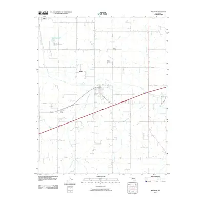
2010 Map of Wellston
USGS Topo · Published 2010About this map
Wellston sits at the center of this Lincoln County landscape, where the Deep Fork river meanders through a network of creeks and prairie. The map documents a rural transition zone where traditional agriculture meets the energy industry, evidenced by the Wellston Oil and Gas Field and the North Captain Oil and Gas Field. Small communities like Fallis and Warwick anchor the corners of the quadrangle, connected by a rigid grid of section roads like Oak Rd and Fallis Rd.
Find a feature on this map
38 named features on this map. Tap any name to fly to it.
Don’t see what you’re looking for? This feature index may not catch every label — zoom into the map to look around manually.
Map Details
Editions of this 2010 Wellston Map
This is the sole edition of this map. No revisions or reprints were ever made.
Other maps of this area

1905 · Chandler
USGS Topo · 1:62,500

1907 · Chandler
USGS Topo · 1:62,500

1908 · Agra
USGS Topo · 1:62,500

1909 · Luther
USGS Topo · 1:62,500

1909 · Perkins
USGS Topo · 1:62,500

1954 · Oklahoma City
USGS Topo · 1:250,000

1956 · Horseshoe Lake
USGS Topo · 1:24,000

1957 · Oklahoma City
USGS Topo · 1:250,000

1963 · Oklahoma City
USGS Topo · 1:250,000
1966 · Luther SE
USGS Topo · 1:24,000