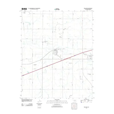
2012 Map of Wellston
USGS Topo · Published 2012About this map
The Deep Fork river corridor and the bustling community of Wellston define this Lincoln County landscape. This 2012 USGS topo sheet reveals the intersection of agriculture and energy extraction, with the Wellston Oil and Gas Field and North Captain Oil and Gas Field spread across the township grids. These fields underscore the region's long-standing connection to Oklahoma's petroleum industry. Smaller settlements like Warwick, Fallis, and the locality of Ingram dot the map, providing a look at the residential patterns that have persisted alongside major thoroughfares and rural section roads.
Find a feature on this map
55 named features on this map. Tap any name to fly to it.
Don’t see what you’re looking for? This feature index may not catch every label — zoom into the map to look around manually.
Map Details
Editions of this 2012 Wellston Map
This is the sole edition of this map. No revisions or reprints were ever made.
Other maps of this area

1905 · Chandler
USGS Topo · 1:62,500

1907 · Chandler
USGS Topo · 1:62,500

1908 · Agra
USGS Topo · 1:62,500

1909 · Luther
USGS Topo · 1:62,500

1909 · Perkins
USGS Topo · 1:62,500

1954 · Oklahoma City
USGS Topo · 1:250,000

1956 · Horseshoe Lake
USGS Topo · 1:24,000

1957 · Oklahoma City
USGS Topo · 1:250,000

1963 · Oklahoma City
USGS Topo · 1:250,000
1966 · Luther SE
USGS Topo · 1:24,000