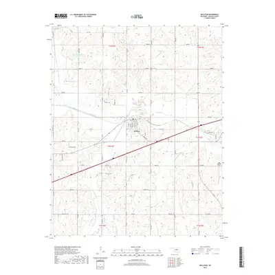
2018 Map of Wellston
USGS Topo · Published 2018About this map
The town of Wellston serves as the central hub of this Lincoln County survey, situated where multiple creek systems converge toward the Deep Fork river. The landscape is defined by the winding paths of Captain Creek, Spring Creek, and Eagle Creek, which create a complex drainage network across the township lines. Local history is anchored by the Wellston Cemetery and Gardner Cemetery, while the modern utility of the land is seen in the Bear-Fall-Coon Creek Site 1 Reservoir to the northwest. This 2018 edition provides a clear view of the town's grid, including streets such as Main Street and Commercial Street, and the outlying Biggs Skypatch Airport to the east. The map captures the interface between the established residential center and the sprawling agricultural sections of T14N R2E and surrounding ranges.
Find a feature on this map
69 named features on this map. Tap any name to fly to it.
Don’t see what you’re looking for? This feature index may not catch every label — zoom into the map to look around manually.
Map Details
Editions of this 2018 Wellston Map
This is the sole edition of this map. No revisions or reprints were ever made.
Other maps of this area

1905 · Chandler
USGS Topo · 1:62,500

1907 · Chandler
USGS Topo · 1:62,500

1908 · Agra
USGS Topo · 1:62,500

1909 · Luther
USGS Topo · 1:62,500

1909 · Perkins
USGS Topo · 1:62,500

1954 · Oklahoma City
USGS Topo · 1:250,000

1956 · Horseshoe Lake
USGS Topo · 1:24,000

1957 · Oklahoma City
USGS Topo · 1:250,000

1963 · Oklahoma City
USGS Topo · 1:250,000
1966 · Luther SE
USGS Topo · 1:24,000