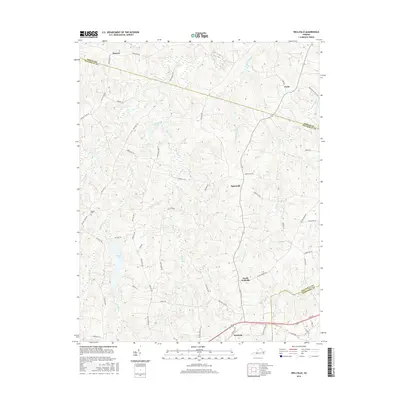
2016 Map of Wellville
USGS Topo · Published 2016About this map
Wellville and its surrounding communities in Nottoway County are defined by a complex network of waterways and rural crossroads. The landscape is deeply etched by the southward-flowing Sweathouse Creek and Bland Creek, while the northern portion of the map transitions into the drainage basins of Deep Creek and Spindlers Run. These creek valleys historically dictated the placement of small agricultural hubs such as Spainville, Earls, and Denaro.
Find a feature on this map
65 named features on this map. Tap any name to fly to it.
Don’t see what you’re looking for? This feature index may not catch every label — zoom into the map to look around manually.
Map Details
Editions of this 2016 Wellville Map
This is the sole edition of this map. No revisions or reprints were ever made.
Other maps of this area

1891 · Farmville
USGS Topo · 1:125,000

1893 · Farmville
USGS Topo · 1:125,000

1897 · Amelia
USGS Topo · 1:125,000

1943 · Amelia
USGS Topo · 1:31,680

1943 · Goodes Bridge
USGS Topo · 1:31,680

1943 · Richmond
USGS Topo · 1:250,000

1947 · Roanoke
USGS Topo · 1:250,000

1949 · Richmond
USGS Topo · 1:250,000
1950 · Wellville
USGS Topo · 1:24,000
1950 · Hebron
USGS Topo · 1:24,000