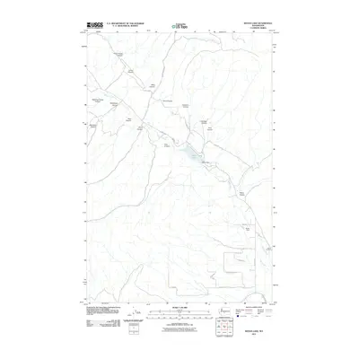
2011 Map of Wenas Lake
USGS Topo · Published 2011About this map
Wenas Lake serves as the central focal point of this Yakima County landscape, formed by the Wenas Dam along the course of Wenas Creek. The surrounding terrain is defined by a series of deeply incised drainages such as Horse Trough Canyon, Black Canyon, and Lady Bug Canyon that cut through the prominent Elk Ridge. In the southern portion of the sheet, the transition from high canyon country to more level ground is marked by Reids Field and the Wenas Cemetery, indicating the areas of more concentrated activity. The road network, including Black Canyon Rd and N Wenas Rd, follows the natural contours of the valley floors, while Dry Creek and Kelley Hollow illustrate the complex drainage patterns that shape this part of Washington state.
Find a feature on this map
36 named features on this map. Tap any name to fly to it.
Don’t see what you’re looking for? This feature index may not catch every label — zoom into the map to look around manually.
Map Details
Editions of this 2011 Wenas Lake Map
This is the sole edition of this map. No revisions or reprints were ever made.
Other maps of this area

1899 · Ellensburg
USGS Topo · 1:125,000

1901 · Ellensburg
USGS Topo · 1:125,000

1950 · Yakima
USGS Topo · 1:250,000
1958 · Ellensburg South
USGS Topo · 1:24,000

1958 · Ellensburg
USGS Topo · 1:62,500
1958 · Selah
USGS Topo · 1:24,000

1958 · Naches
USGS Topo · 1:24,000

1958 · Yakima
USGS Topo · 1:250,000

1961 · Yakima
USGS Topo · 1:250,000
1971 · Milk Canyon
USGS Topo · 1:24,000