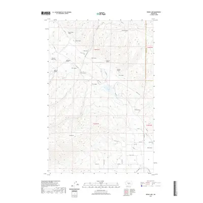
2020 Map of Wenas Lake
USGS Topo · Published 2020About this map
Cleman Mtn and Umtanum Ridge dominate the landscape in this region of Yakima County, where the topography is defined by a dense network of drainages and high relief. The central corridor is shaped by the flow of Wenas Cr, which feeds into Wenas Lake, a focal point for the surrounding rural roads and small-scale developments. The map reveals a land characterized by numerous named canyons, such as Black Canyon, Spud Canyon, and Lady Bug Canyon, suggesting a history of local geographic identification tied to specific draws and valleys.
Find a feature on this map
46 named features on this map. Tap any name to fly to it.
Don’t see what you’re looking for? This feature index may not catch every label — zoom into the map to look around manually.
Map Details
Editions of this 2020 Wenas Lake Map
This is the sole edition of this map. No revisions or reprints were ever made.
Other maps of this area

1899 · Ellensburg
USGS Topo · 1:125,000

1901 · Ellensburg
USGS Topo · 1:125,000

1950 · Yakima
USGS Topo · 1:250,000
1958 · Ellensburg South
USGS Topo · 1:24,000

1958 · Ellensburg
USGS Topo · 1:62,500
1958 · Selah
USGS Topo · 1:24,000

1958 · Naches
USGS Topo · 1:24,000

1958 · Yakima
USGS Topo · 1:250,000

1961 · Yakima
USGS Topo · 1:250,000
1971 · Milk Canyon
USGS Topo · 1:24,000