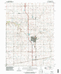
1996 Map of Wenona
USGS Topo · Published 1997About this map
Wenona serves as the central hub of this prairie landscape, straddling the border between La Salle and Marshall Counties. The town's grid is well-established, anchored by the Fieldcrest Middle School and multiple burial grounds including Wenona Cem and St Marys Cem. A strong agricultural and transit character is evident through the path of several watercourses like Sandy Creek and Judd Creek, which cut through the surrounding townships of Hope, Richland, and Evans.
Find a feature on this map
28 named features on this map. Tap any name to fly to it.
Don’t see what you’re looking for? This feature index may not catch every label — zoom into the map to look around manually.
Map Details
Editions of this 1996 Wenona Map
This is the sole edition of this map. No revisions or reprints were ever made.
Other maps of this area

1925 · Streator
USGS Topo · 1:62,500

1927 · Streator
USGS Topo · 1:62,500

1934 · Wenona
USGS Topo · 1:48,000

1939 · Wenona
USGS Topo · 1:62,500

1955 · Minonk
USGS Topo · 1:62,500

1958 · Flanagan
USGS Topo · 1:62,500

1958 · Aurora
USGS Topo · 1:250,000

1958 · Peoria
USGS Topo · 1:250,000

1961 · Aurora
USGS Topo · 1:250,000

1961 · Peoria
USGS Topo · 1:250,000