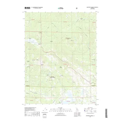
2018 Map of Wentworth Springs
USGS Topo · Published 2018About this map
Wentworth Springs and Mineral Springs sit at the center of this high-elevation landscape, where the northern reaches of the Eldorado National Forest meet the southern edge of the Tahoe National Forest. The 2018 survey reveals a terrain defined by granite peaks and alpine meadows, punctuated by substantial water bodies like Loon Lake and the Hell Hole Reservoir. The map documents a complex network of seasonal drainage and glacial features, including the Rubicon River and a series of high-altitude basins like Mud Lakes and Barts Valley. Of particular interest to recreational historians is the path of the Rubicon Jeep trail and the Telemark Loop, illustrating how modern back-country transit follows the same natural corridors as the earlier survey lines. From the heights of McKinstry Peak and Devils Peak down to the secluded Laddies Cove, the map provides a comprehensive view of this Sierra Nevada wilderness.
Find a feature on this map
71 named features on this map. Tap any name to fly to it.
Don’t see what you’re looking for? This feature index may not catch every label — zoom into the map to look around manually.
Map Details
Editions of this 2018 Wentworth Springs Map
This is the sole edition of this map. No revisions or reprints were ever made.
Other maps of this area

1889 · Pyramid Peak
USGS Topo · 1:125,000

1891 · Truckee
USGS Topo · 1:125,000

1891 · Pyramid Peak
USGS Topo · 1:125,000

1893 · Truckee
USGS Topo · 1:125,000

1895 · Pyramid Peak
USGS Topo · 1:125,000

1895 · Truckee
USGS Topo · 1:125,000

1896 · Pyramid Peak
USGS Topo · 1:125,000

1932 · Truckee
USGS Topo · 1:96,000

1940 · Truckee
USGS Topo · 1:125,000

1947 · Sacramento
USGS Topo · 1:250,000