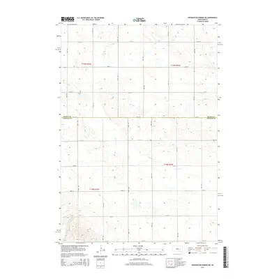
2015 Map of Wessington Springs NE
USGS Topo · Published 2015About this map
The agricultural plains at the border of Beadle Co and Jerauld Co are defined by a strict grid of section roads and the meandering drainage of the James River basin. This landscape is marked by the presence of Earlville Cem, a lone landmark in the northwest corner that serves as a quiet record of early homesteading history in Chery Township. The terrain is bisected by the seasonal flow of Firesteel Cr and Sand Cr, which cut through the prairie sod. The network of corridors like 382nd Ave and 220th St reveals a high-precision survey of the Public Land Survey System, illustrating how the townships of t109n r65w and t108n r64w were organized for large-scale farming and ranching in the twenty-first century.
Find a feature on this map
24 named features on this map. Tap any name to fly to it.
Don’t see what you’re looking for? This feature index may not catch every label — zoom into the map to look around manually.
Map Details
Editions of this 2015 Wessington Springs NE Map
This is the sole edition of this map. No revisions or reprints were ever made.
Other maps of this area

1898 · Huron
USGS Topo · 1:125,000

1951 · Wessington SE
USGS Topo · 1:24,000

1951 · Wessington SW
USGS Topo · 1:24,000

1953 · Huron
USGS Topo · 1:250,000

1954 · Huron
USGS Topo · 1:250,000

1973 · Wessington Springs NE
USGS Topo · 1:24,000

1973 · Wessington Springs
USGS Topo · 1:24,000

1973 · Wessington Springs NW
USGS Topo · 1:24,000
1973 · Virgil
USGS Topo · 1:24,000
1973 · Woonsocket NW
USGS Topo · 1:24,000