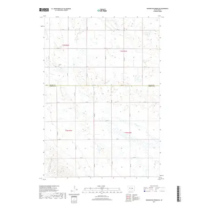
2017 Map of Wessington Springs NE
USGS Topo · Published 2017About this map
Earlville Cem sits as a quiet landmark amidst the vast agricultural section lines of the South Dakota prairie during this 2017 survey. The landscape is defined by the boundary between Beadle Co and Jerauld Co, where a network of gravel and section roads like 217th St and 382nd Ave creates a rigid grid across the terrain. Hydrological features provide the only breaks in the geometric pattern, with the headwaters of Sand Creek and the meandering path of Firesteel Cr cutting through the fields. This map illustrates the enduring township-and-range settlement pattern typical of the Great Plains, showing how modern county lines and infrastructure continue to follow the original land surveys of the late 19th century.
Find a feature on this map
25 named features on this map. Tap any name to fly to it.
Don’t see what you’re looking for? This feature index may not catch every label — zoom into the map to look around manually.
Map Details
Editions of this 2017 Wessington Springs NE Map
This is the sole edition of this map. No revisions or reprints were ever made.
Other maps of this area

1898 · Huron
USGS Topo · 1:125,000

1951 · Wessington SE
USGS Topo · 1:24,000

1951 · Wessington SW
USGS Topo · 1:24,000

1953 · Huron
USGS Topo · 1:250,000

1954 · Huron
USGS Topo · 1:250,000

1973 · Wessington Springs NE
USGS Topo · 1:24,000

1973 · Wessington Springs
USGS Topo · 1:24,000

1973 · Wessington Springs NW
USGS Topo · 1:24,000
1973 · Virgil
USGS Topo · 1:24,000
1973 · Woonsocket NW
USGS Topo · 1:24,000