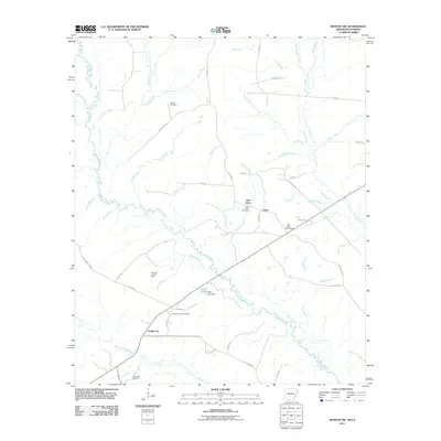
2011 Map of Wesson SW
USGS Topo · Published 2011About this map
Cornie Bayou and its numerous tributaries, including Black Branch, Jordon Branch, and Little Cornie Bayou, define the drainage patterns of this South Arkansas landscape. The presence of the Tubal Oil and Gas Field and the Lick Creek Oil Field points to the region's long-standing reliance on petroleum extraction. Small rural settlements like Dodge City, Tubal, and New Hope serve as the primary human hubs, connected by a network of local roads such as Union Road 203 and Atlanta Rd. Genealogists will find several burial sites noted, including the Union Arkansas Cemetery, Salem Cemetery, and Jolly Chapel Cemetery. The terrain is also marked by human engineering at Lewis Lake Dam, while former transportation routes are preserved via labels like Tram Rd, reflecting the area's timber or industrial heritage.
Find a feature on this map
59 named features on this map. Tap any name to fly to it.
Don’t see what you’re looking for? This feature index may not catch every label — zoom into the map to look around manually.
Map Details
Editions of this 2011 Wesson SW Map
This is the sole edition of this map. No revisions or reprints were ever made.
Other maps of this area

1951 · Summerfield
USGS Topo · 1:62,500

1952 · Homer
USGS Topo · 1:62,500

1953 · El Dorado
USGS Topo · 1:250,000

1955 · Shreveport
USGS Topo · 1:250,000

1956 · Shreveport
USGS Topo · 1:250,000

1957 · El Dorado
USGS Topo · 1:250,000

1958 · El Dorado
USGS Topo · 1:250,000

1960 · El Dorado
USGS Topo · 1:250,000

1966 · Spotville
USGS Topo · 1:24,000
1971 · Wesson
USGS Topo · 1:24,000