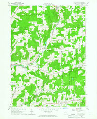
1964 Map of West Almond
USGS Topo · Published 1966About this map
State Reforestation Area lands dominate this Allegany County landscape, where the regrowth of timber marks a transition from earlier intensive farming. Small rural hamlets like West Almond, Scholes, and Bennetts are connected by a network of gravel roads and winding valleys carved by Angelica Creek and Black Creek. Evidence of earlier industrial infrastructure is visible in the Railroad Grade and Old RR Grade that traverse the territory, alongside a County Home and several scattered gravel pits. High elevations such as Peacock Hill, Bald Mountain, and Jersey Hill provide topographic variety, with the latter featuring a Lookout Tower and Picnic Area near Palmers Pond. The settlement pattern follows the drainages, with the village of Phillips Creek situated along its namesake waterway in the southern portion of the survey.
Find a feature on this map
52 named features on this map. Tap any name to fly to it.
Don’t see what you’re looking for? This feature index may not catch every label — zoom into the map to look around manually.
Map Details
Editions of this 1964 West Almond Map
2 editions found
Other maps of this area

1906 · Angelica
USGS Topo · 1:62,500

1916 · Canaseraga
USGS Topo · 1:62,500

1925 · Belmont
USGS Topo · 1:62,500

1926 · Wellsville
USGS Topo · 1:62,500

1939 · Belmont
USGS Topo · 1:62,500

1940 · Canaseraga
USGS Topo · 1:62,500

1941 · Angelica
USGS Topo · 1:62,500

1950 · Elmira
USGS Topo · 1:250,000

1958 · Elmira
USGS Topo · 1:250,000

1960 · Buffalo
USGS Topo · 1:250,000