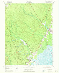
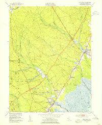
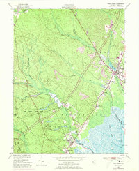
1951 Map of West Creek
USGS Topo · Published 1972About this map
The coastal lowlands and Pine Barrens of Ocean County are documented here in the early 1950s, a period marked by the arrival of the Garden State Parkway. This major thoroughfare is shown under construction, cutting a diagonal path through the Stafford and Eagleswood townships. Near Manahawkin, the landscape is defined by the proximity of Manahawkin Lake and the agricultural footprint of numerous Cranberry Bogs.
Find a feature on this map
49 named features on this map. Tap any name to fly to it.
Don’t see what you’re looking for? This feature index may not catch every label — zoom into the map to look around manually.
Map Details
Editions of this 1951 West Creek Map
5 editions found


Other maps of this area

1884 · Whitings
USGS Topo · 1:62,500

1888 · Barnegat
USGS Topo · 1:62,500

1888 · Little Egg Harbor
USGS Topo · 1:62,500

1888 · Long Beach
USGS Topo · 1:62,500

1888 · Whitings
USGS Topo · 1:62,500

1893 · Little Egg Harbor
USGS Topo · 1:62,500

1893 · Long Beach
USGS Topo · 1:62,500

1893 · Barnegat
USGS Topo · 1:62,500

1898 · Barnegat
USGS Topo · 1:62,500

1919 · Long Beach
USGS Topo · 1:62,500
Featured Places
- Stafford Township, NJ
- Barnegat Township, NJ
- Little Egg Harbor Township, NJ
- Eagleswood Township, NJ
- Staffordville, Eagleswood Township