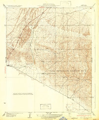
1932 Map of West Elk Hills
USGS Topo · Published 1932About this map
The Naval Petroleum Reserve No 1 dominates the complex terrain of the Elk Hills in this 1932 topographic study. This area of Kern County was a critical site for American energy security during the early twentieth century, as evidenced by the extensive federal holdings shown here. Along the western edge of the hills, the settlement of McKittrick and the nearby Asphalto mark the focal points of the local economy and transport. The Southern Pacific railroad line skirts the base of the hills, providing a vital link for the region's industrial output. The McKittrick Bakersfield Highway cuts across the northern flats, connecting these oil-rich lands to the wider San Joaquin Valley. At Hillcrest Point, the map reveals the dramatic elevation changes that characterize this landscape, showing how early twentieth-century infrastructure adapted to the region's unique geography.
Find a feature on this map
8 named features on this map. Tap any name to fly to it.
Don’t see what you’re looking for? This feature index may not catch every label — zoom into the map to look around manually.
Map Details
Editions of this 1932 West Elk Hills Map
2 editions found
Other maps of this area

1910 · Buena Vista Lake
USGS Topo · 1:125,000

1912 · McKittrick
USGS Topo · 1:125,000

1912 · Buena Vista Lake
USGS Topo · 1:125,000

1931 · Lokern
USGS Topo · 1:31,680

1932 · West Elk Hills
USGS Topo · 1:31,680

1932 · East Elk Hills
USGS Topo · 1:31,680
1932 · Buttonwillow
USGS Topo · 1:31,680

1934 · Lokern
USGS Topo · 1:31,680
1942 · Buttonwillow
USGS Topo · 1:62,500
1943 · Belridge
USGS Topo · 1:31,680