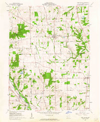
1961 Map of West Elkton
USGS Topo · Published 1962About this map
West Elkton serves as the central hub of this agrarian landscape, situated near the boundary of Somers and Gratis townships. The map illustrates a well-developed network of rural roads such as the Camden West Elkton Road and Stubbs Road, connecting isolated settlements like Greenbush and Beechwood. In the southwest, the Pennsylvania railroad line follows the valley of Seven Mile Creek toward Collinsville, passing a Gaging Station and the Collinsville Cem. The terrain is characterized by a series of drainage basins, with Elk Creek and Nine Mile Creek carving through the farmland. Local social centers are evident in the placement of the Shawnee Sch, the Friends Ch, and the Rush Run Wildlife Area, which provides a significant break in the otherwise systematic grid of cultivated fields.
Find a feature on this map
37 named features on this map. Tap any name to fly to it.
Don’t see what you’re looking for? This feature index may not catch every label — zoom into the map to look around manually.
Map Details
Editions of this 1961 West Elkton Map
2 editions found
Other maps of this area

1904 · Mason
USGS Topo · 1:62,500

1906 · Mason
USGS Topo · 1:62,500

1908 · Miamisburg
USGS Topo · 1:62,500

1911 · Oxford
USGS Topo · 1:62,500

1915 · Hamilton
USGS Topo · 1:62,500

1917 · Hamilton
USGS Topo · 1:62,500

1953 · Cincinnati
USGS Topo · 1:250,000

1955 · Hamilton
USGS Topo · 1:24,000
1955 · Trenton
USGS Topo · 1:24,000
1955 · Millville
USGS Topo · 1:24,000