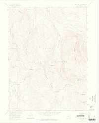
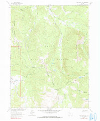
1962 Map of West Fork Lake
USGS Topo · Published 1964About this map
Routt National Forest dominates this high-altitude landscape along the border of Jackson and Routt Counties. This 1962 field-checked survey reveals a complex network of seasonal transport and water management, including the Stock Driveway and multiple Pack Trails that cross the Continental Divide and the Sierra Madre range. The drainage systems of the Encampment River and its various forks, such as the West Fork Encampment River, characterize the northern sections, while the Middle Fork Little Snake River flows to the southwest. High-country water features like West Fork Lake, Manzanares Lake, and Sanchez Lakes are depicted among the peaks, illustrating the remote hydrology of the region before modern development altered these alpine corridors.
Find a feature on this map
26 named features on this map. Tap any name to fly to it.
Don’t see what you’re looking for? This feature index may not catch every label — zoom into the map to look around manually.
Map Details
Editions of this 1962 West Fork Lake Map
5 editions found
Other maps of this area

1911 · Hahns Peak
USGS Topo · 1:125,000

1913 · Hahns Peak
USGS Topo · 1:125,000

1939 · Saratoga
USGS Topo · 1:125,000

1954 · Rawlins
USGS Topo · 1:250,000

1954 · Craig
USGS Topo · 1:250,000

1955 · Davis Peak
USGS Topo · 1:24,000

1955 · Mount Zirkel
USGS Topo · 1:24,000

1956 · Pearl
USGS Topo · 1:62,500

1957 · Craig
USGS Topo · 1:250,000

1958 · Rawlins
USGS Topo · 1:250,000