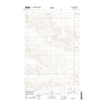
2014 Map of West Fork NE
USGS Topo · Published 2014About this map
Hell Cr meanders through the drainages of northeastern Montana in this 2014 survey by the U.S. Geological Survey. The landscape is defined by the sharp relief of Shipstead Coulee, which cuts through the southeastern corner of the quadrangle. This area of the Wolf Point District remains primarily rural and dominated by large-scale agricultural and grazing land divisions. A sparse network of gravel roads provides the only access through this terrain, with Peerless Rd running north-south through the center and Fladager Rd tracing the hills to the east. Modern land management is evidenced by the detailed Public Land Survey System grid, marking townships like t34n r45e, which organize the remote territory of Roosevelt County.
Find a feature on this map
11 named features on this map. Tap any name to fly to it.
Don’t see what you’re looking for? This feature index may not catch every label — zoom into the map to look around manually.
Map Details
Editions of this 2014 West Fork NE Map
This is the sole edition of this map. No revisions or reprints were ever made.
Other maps of this area

1954 · Wolf Point
USGS Topo · 1:250,000

1958 · Wolf Point
USGS Topo · 1:250,000

1973 · Horseshoe Basin
USGS Topo · 1:24,000

1973 · West Fork NE
USGS Topo · 1:24,000

1973 · Peerless
USGS Topo · 1:24,000

1973 · Killenbeck Reservoir
USGS Topo · 1:24,000

1973 · Haugens Hill
USGS Topo · 1:24,000

1973 · Peerless 4 SW
USGS Topo · 1:24,000

1973 · Poplar Coulee
USGS Topo · 1:24,000
1973 · West Fork
USGS Topo · 1:24,000