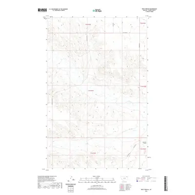
2020 Map of West Fork NE
USGS Topo · Published 2020About this map
W Fork Poplar River meanders through this section of Daniels County, Montana, defining a landscape of deeply etched drainages and high plateaus. The drainage patterns are clearly marked by features such as Hell Cr and the prominent Shipstead Coulee in the southeastern quadrant. This modern 2020 survey reflects a rural infrastructure built upon long-standing township and range divisions, where local transportation relies on a network of named section-line roads. Many of these thoroughfares, including Fladager Rd, Shipstead Rd, and Peerless Lustre Rd, likely carry the names of early homesteading families or local landmarks, providing essential clues for genealogists and local historians tracing the development of this northern Montana prairie. The topographical detail reveals the complex network of draws and ridges that characterize the area's grazing land and dryland farming environment.
Find a feature on this map
15 named features on this map. Tap any name to fly to it.
Don’t see what you’re looking for? This feature index may not catch every label — zoom into the map to look around manually.
Map Details
Editions of this 2020 West Fork NE Map
This is the sole edition of this map. No revisions or reprints were ever made.
Other maps of this area

1954 · Wolf Point
USGS Topo · 1:250,000

1958 · Wolf Point
USGS Topo · 1:250,000

1973 · Horseshoe Basin
USGS Topo · 1:24,000

1973 · West Fork NE
USGS Topo · 1:24,000

1973 · Peerless
USGS Topo · 1:24,000

1973 · Killenbeck Reservoir
USGS Topo · 1:24,000

1973 · Haugens Hill
USGS Topo · 1:24,000

1973 · Peerless 4 SW
USGS Topo · 1:24,000

1973 · Poplar Coulee
USGS Topo · 1:24,000
1973 · West Fork
USGS Topo · 1:24,000