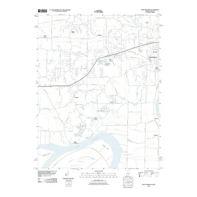
2010 Map of West Franklin
USGS Topo · Published 2010About this map
The Ohio River defines the southern boundary of this region, winding through Cypress Bend and framing the large landmass of Diamond Island. This riverfront landscape transitions from the low-lying wetlands of Cypress Slough and Deep Slough to the higher ground of the Evansville suburbs. The northern half of the map shows the expansion of Indiana State University and its surrounding infrastructure, including Indiana State University Lake.
Find a feature on this map
87 named features on this map. Tap any name to fly to it.
Don’t see what you’re looking for? This feature index may not catch every label — zoom into the map to look around manually.
Map Details
Editions of this 2010 West Franklin Map
This is the sole edition of this map. No revisions or reprints were ever made.
Other maps of this area

1901 · Haubstadt
USGS Topo · 1:62,500

1903 · Haubstadt
USGS Topo · 1:62,500

1903 · New Harmony
USGS Topo · 1:62,500

1903 · Patoka
USGS Topo · 1:125,000

1914 · Henderson
USGS Topo · 1:48,000

1916 · Henderson
USGS Topo · 1:62,500

1917 · Uniontown
USGS Topo · 1:62,500

1938 · New Harmony
USGS Topo · 1:62,500

1952 · Evansville
USGS Topo · 1:24,000
1952 · Henderson
USGS Topo · 1:24,000