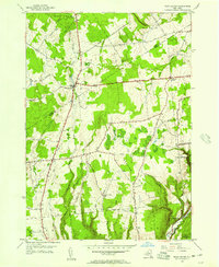
1955 Map of West Leyden
USGS Topo · Published 1957About this map
West Leyden serves as a central point in this mid-century portrait of the upper Mohawk Valley, where the borders of Lewis and Oneida Counties meet. The landscape is defined by the headwaters of the Mohawk River, specifically the East Branch and West Branch, which carve through a mosaic of woodlots and agricultural clearings. To the south, the village of Ava sits amidst a network of rural routes like Drofoot Road and Tuffey Road, while the smaller settlement of Flint Town occupies the valley of Flint Brook. A significant engineering relic, the Black River Canal, is visible in the southeastern corner near Dunn Brook, marking the era of inland waterway transport. Higher elevations such as Webster Hill and Jackson Hill overlook widespread State Reforestation Areas, signaling a shift toward forest conservation in the mid-1950s. Genealogists will find the West Leyden Cem and Thornton Cem clearly marked among these Tug Hill upland communities.
Find a feature on this map
37 named features on this map. Tap any name to fly to it.
Don’t see what you’re looking for? This feature index may not catch every label — zoom into the map to look around manually.
Map Details
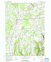
Editions of this 1955 West Leyden Map
2 editions found
Other maps of this area

1904 · Boonville
USGS Topo · 1:62,500

1905 · Port Leyden
USGS Topo · 1:62,500

1905 · Taberg
USGS Topo · 1:62,500

1906 · Highmarket
USGS Topo · 1:62,500

1907 · Port Leyden
USGS Topo · 1:62,500

1940 · Port Leyden
USGS Topo · 1:62,500

1943 · Lee Center
USGS Topo · 1:31,680

1943 · High Market
USGS Topo · 1:24,000

1944 · Point Rock
USGS Topo · 1:31,680
1944 · Highmarket
USGS Topo · 1:31,680