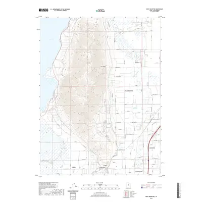
2020 Map of West Mountain
USGS Topo · Published 2020About this map
West Mtn dominates the central landscape of this Utah County quadrangle, forming a massive topographic barrier between Utah Lake to the west and the developed agricultural valleys to the east. The terrain transitions from the steep elevations of Long Canyon and Long Ridge down to the fertile flats near Payson and Santaquin. Water management is a defining characteristic of the eastern plains, evidenced by a network of ditches and drainage features like Benjamin Slough, Spring Cr, and the Tanner Reservoir. To the south, the settlement of Genola sits near the base of the mountain, while Keigley marks the southern approach toward Goshen Gap. The shoreline of Utah Lake and the marshy expanses of White Lake provide a stark contrast to the arid, complex contours of the mountain range, illustrating the vital relationship between the high ground and the irrigated basins below.
Find a feature on this map
59 named features on this map. Tap any name to fly to it.
Don’t see what you’re looking for? This feature index may not catch every label — zoom into the map to look around manually.
Map Details
Editions of this 2020 West Mountain Map
This is the sole edition of this map. No revisions or reprints were ever made.
Other maps of this area

1885 · Salt Lake
USGS Topo · 1:250,000

1885 · Manti
USGS Topo · 1:250,000

1895 · Manti
USGS Topo · 1:250,000

1948 · Spanish Fork
USGS Topo · 1:24,000

1948 · Provo
USGS Topo · 1:24,000

1949 · Provo
USGS Topo · 1:62,500

1950 · Provo
USGS Topo · 1:24,000

1950 · Spanish Fork
USGS Topo · 1:24,000

1950 · West Mountain
USGS Topo · 1:24,000
1950 · Goshen Valley North
USGS Topo · 1:24,000