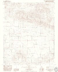
1986 Map of West of Drinkwater Lake
USGS Topo · Published 1986About this map
The Fort Irwin Military Reservation occupies a significant portion of this high desert terrain in the mid-1980s. This specialized survey focuses on a remote sector of San Bernardino County dominated by the Granite Mountains, which rise sharply from the basin floor. The landscape is characterized by its stark, undeveloped character, defined primarily by military boundaries and topographic relief rather than civilian settlement. Mapping at this scale reveals the intricate drainage patterns and ridge lines that dictate movement through this restricted government landscape. The absence of traditional towns or industrial infrastructure underscores the area's primary use as a training and maneuvers ground, where the natural landforms themselves become the defining landmarks of the territory.
Find a feature on this map
4 named features on this map. Tap any name to fly to it.
Don’t see what you’re looking for? This feature index may not catch every label — zoom into the map to look around manually.
Map Details
Editions of this 1986 West of Drinkwater Lake Map
2 editions found
Other maps of this area

1933 · Avawatz Mountains
USGS Topo · 1:250,000

1947 · Trona
USGS Topo · 1:250,000

1948 · Trona
USGS Topo · 1:250,000

1948 · Quail Mountains
USGS Topo · 1:62,500

1948 · Leach Lake
USGS Topo · 1:62,500

1948 · Goldstone Lake
USGS Topo · 1:62,500

1948 · Tiefort Mountains
USGS Topo · 1:62,500

1951 · Goldstone Lake
USGS Topo · 1:62,500

1951 · Tiefort Mountains
USGS Topo · 1:62,500

1951 · Quail Mountains
USGS Topo · 1:62,500