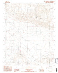
1986 Map of West of Drinkwater Lake
USGS Topo · Published 1986About this map
The Granite Mountains dominate the northern terrain of this high desert region in San Bernardino County, where dramatic elevation changes define the landscape. This mid-1980s provisional survey focuses heavily on the eastern reaches of the Fort Irwin Military Reservation, a site central to the era's desert training operations. The map provides a detailed view of the rugged topography, including several high peaks such as Nelson in the southern portion of the sheet. Surveyed through aerial photography and field checking in the early 1980s, the map reveals a landscape largely devoid of civilian infrastructure, emphasizing instead the vastness of the federal military reservation and the natural barriers formed by the arid mountain ranges of the Mojave.
Find a feature on this map
5 named features on this map. Tap any name to fly to it.
Don’t see what you’re looking for? This feature index may not catch every label — zoom into the map to look around manually.
Map Details
Editions of this 1986 West of Drinkwater Lake Map
2 editions found
Other maps of this area

1933 · Avawatz Mountains
USGS Topo · 1:250,000

1947 · Trona
USGS Topo · 1:250,000

1948 · Trona
USGS Topo · 1:250,000

1948 · Quail Mountains
USGS Topo · 1:62,500

1948 · Leach Lake
USGS Topo · 1:62,500

1948 · Goldstone Lake
USGS Topo · 1:62,500

1948 · Tiefort Mountains
USGS Topo · 1:62,500

1951 · Goldstone Lake
USGS Topo · 1:62,500

1951 · Tiefort Mountains
USGS Topo · 1:62,500

1951 · Quail Mountains
USGS Topo · 1:62,500