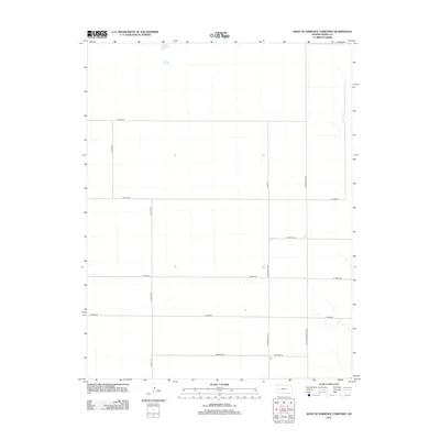
2012 Map of West of Eminence Cemetery
USGS Topo · Published 2012About this map
Finney County’s agrarian layout is clearly defined on this 2012 survey, revealing the precise section-line grid that governs this part of the High Plains. The landscape is characterized by its organized road network, with major corridors like N Scott Rd and N Mennonite Rd running north-south to segment the vast agricultural tracts. To the east, the drainage patterns of small seasonal stream beds begin to disrupt the geometry near N Little Mennonite Rd. While the area is sparsely populated, the map provides essential data for researchers tracking the evolution of rural land divisions and family-named routes such as E Wiebe Rd and Barlow Rd. This survey captures the region just before further modern developments or changes in land management, preserving the spatial arrangement of a late twentieth-century farming community.
Find a feature on this map
11 named features on this map. Tap any name to fly to it.
Don’t see what you’re looking for? This feature index may not catch every label — zoom into the map to look around manually.
Map Details
Editions of this 2012 West of Eminence Cemetery Map
This is the sole edition of this map. No revisions or reprints were ever made.
Other maps of this area

1940 · Scott City
USGS Topo · 1:62,500

1944 · Tennis
USGS Topo · 1:62,500

1951 · Scott City
USGS Topo · 1:62,500

1955 · Scott City
USGS Topo · 1:250,000

1958 · Scott City
USGS Topo · 1:250,000
1974 · Scott City 4 SW
USGS Topo · 1:24,000
1974 · Scott City 4 SE
USGS Topo · 1:24,000
1974 · Scott City 4 NW
USGS Topo · 1:24,000

1974 · Amy SE
USGS Topo · 1:24,000

1974 · Scott City 4 NE
USGS Topo · 1:24,000