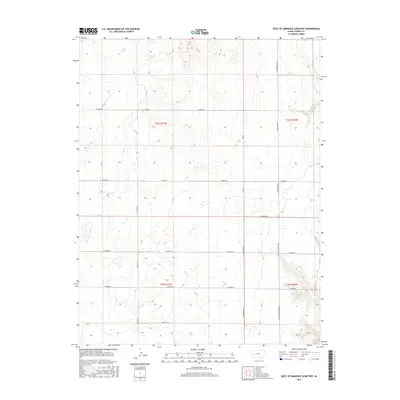
2016 Map of West of Eminence Cemetery
USGS Topo · Published 2016About this map
High plains terrain and agricultural section lines define this corner of Finney County, Kansas. The landscape is marked by a precise grid of rural roads, including N Mennonite Rd and N Little Mennonite Rd, which reflect the cultural and religious heritage of the farming communities settled here. The area is divided among several townships, including t21s r31w, t21s r30w, t22s r31w, and t22s r30w, showcasing the systematic land division of the American West. The survey illustrates the local transportation network through thoroughfares such as E Mead Rd, E Gano Rd, and E Tennis Rd. This 2016 survey provides a clear look at the modern rural infrastructure, including E Wiebe Rd and E Barlow Rd, in an area defined by wide-open spaces and localized name-bearing landmarks.
Find a feature on this map
15 named features on this map. Tap any name to fly to it.
Don’t see what you’re looking for? This feature index may not catch every label — zoom into the map to look around manually.
Map Details
Editions of this 2016 West of Eminence Cemetery Map
This is the sole edition of this map. No revisions or reprints were ever made.
Other maps of this area

1940 · Scott City
USGS Topo · 1:62,500

1944 · Tennis
USGS Topo · 1:62,500

1951 · Scott City
USGS Topo · 1:62,500

1955 · Scott City
USGS Topo · 1:250,000

1958 · Scott City
USGS Topo · 1:250,000
1974 · Scott City 4 SW
USGS Topo · 1:24,000
1974 · Scott City 4 SE
USGS Topo · 1:24,000
1974 · Scott City 4 NW
USGS Topo · 1:24,000

1974 · Amy SE
USGS Topo · 1:24,000

1974 · Scott City 4 NE
USGS Topo · 1:24,000