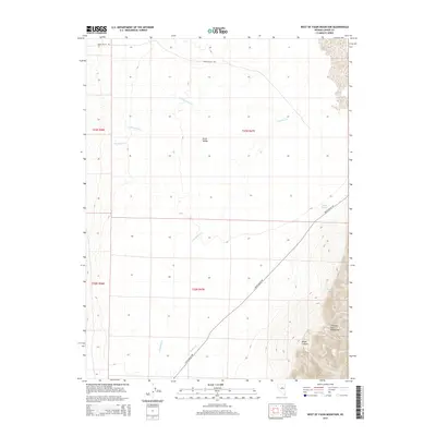
2015 Map of West of Fagin Mountain
USGS Topo · Published 2015About this map
Grass Valley dominates the central portion of this 2015 survey, where the wide basin floor meets the steep ascent of the Simpson Park Mountains in the southeast. This portion of the Nevada interior is defined by a series of intermittent watercourses, including Corral Canyon Cr, Cowboy Rest Cr, and Rosebush Cr, which drain from the higher elevations toward the valley floor. Grass Valley Rd serves as the primary corridor through the area, skirting the base of the mountains as it crosses Callaghan Cr and Indian Cr. The map captures a high-desert environment where water remains the most significant landmark, evidenced by the named sources of Valley Spring and Twin Springs near the entrance to Wood Canyon.
Find a feature on this map
15 named features on this map. Tap any name to fly to it.
Don’t see what you’re looking for? This feature index may not catch every label — zoom into the map to look around manually.
Map Details
Editions of this 2015 West of Fagin Mountain Map
This is the sole edition of this map. No revisions or reprints were ever made.
Other maps of this area

1926 · Roberts Mountains
USGS Topo · 1:250,000

1929 · Roberts Mountains
USGS Topo · 1:250,000

1955 · Millett
USGS Topo · 1:250,000

1956 · Mount Callaghan
USGS Topo · 1:62,500

1956 · Walti Hot Springs
USGS Topo · 1:62,500

1956 · Hall Creek
USGS Topo · 1:62,500

1956 · Ackerman Canyon
USGS Topo · 1:62,500

1959 · Millett
USGS Topo · 1:250,000

1979 · Simpson Park Mtns
USGS Topo · 1:100,000
1986 · Walti Hot Springs
USGS Topo · 1:24,000