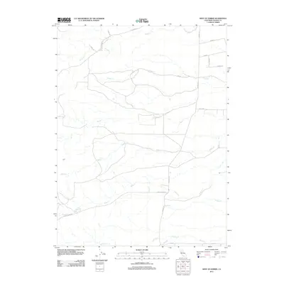
2012 Map of West of Gerber
USGS Topo · Published 2012About this map
Elder Cr and Red Bank Cr wind through this rural section of Tehama County, defining a landscape of complex drainage systems and creek beds. The map illustrates a transition from the higher terrain to the west toward the agricultural plains of the Sacramento Valley. A sparse network of roads, including the long stretches of Paskenta Rd and Rancho Tehama Rd, connects the scattered holdings in this dry-creek country. Local geography is largely dictated by these intermittent seasonal waterways such as Oat Cr, Willow Cr, and Coyote Cr, which have shaped the movement and settlement patterns of the region. The presence of several family or place-named routes like Carey Ln and Shawn Ln suggests the private ranching and residential land use that persists in the area west of the more developed valley floor.
Find a feature on this map
18 named features on this map. Tap any name to fly to it.
Don’t see what you’re looking for? This feature index may not catch every label — zoom into the map to look around manually.
Map Details
Editions of this 2012 West of Gerber Map
This is the sole edition of this map. No revisions or reprints were ever made.
Other maps of this area

1890 · Red Bluff
USGS Topo · 1:250,000

1894 · Red Bluff
USGS Topo · 1:250,000

1904 · Vina
USGS Topo · 1:62,500

1905 · Tehama
USGS Topo · 1:62,500

1944 · Flournoy
USGS Topo · 1:62,500

1950 · Gerber
USGS Topo · 1:24,000

1951 · Gerber
USGS Topo · 1:24,000
1951 · Corning
USGS Topo · 1:24,000

1951 · Red Bluff East
USGS Topo · 1:24,000

1951 · West of Gerber
USGS Topo · 1:24,000