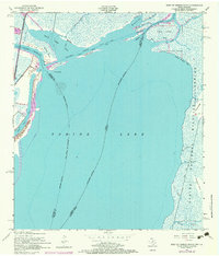
1957 Map of West of Greens Bayou
USGS Topo · Published 1979About this map
The Sabine Lake estuary defines this coastal borderland, where the Sabine River and Neches River converge amidst a complex network of bayous and marshy islands. Deep-water commerce is evident through the Intracoastal Waterway and a Project Depth 12 Feet Canal, illustrating the mid-century industrial importance of these shipping lanes. The eastern shore is dominated by the Sabine National Wildlife Refuge, where features like Pines Ridge and Whisky Bayou rise from the wetlands. Numerous smaller landmasses such as Sabine Island, Stewts Island, and Humble Island fragment the river delta, showing the intricate natural drainage system before modern coastal modifications. The map also captures the Port Arthur City Boundary and the precise state line dividing Texas and Louisiana as it threads through these shifting waters.
Find a feature on this map
36 named features on this map. Tap any name to fly to it.
Don’t see what you’re looking for? This feature index may not catch every label — zoom into the map to look around manually.
Map Details
Editions of this 1957 West of Greens Bayou Map
4 editions found
Other maps of this area

1926 · Terry
USGS Topo · 1:24,000

1932 · Orange
USGS Topo · 1:62,500

1932 · Port Arthur NE
USGS Topo · 1:31,680

1934 · Johnsons Bayou
USGS Topo · 1:24,000

1934 · Greens Bayou
USGS Topo · 1:24,000

1935 · Greens Bayou
USGS Topo · 1:31,680

1935 · Johnsons Bayou
USGS Topo · 1:31,680

1943 · West of Johnson Bayou
USGS Topo · 1:24,000

1943 · West of Greens Bayou
USGS Topo · 1:24,000

1943 · Orangefield
USGS Topo · 1:24,000