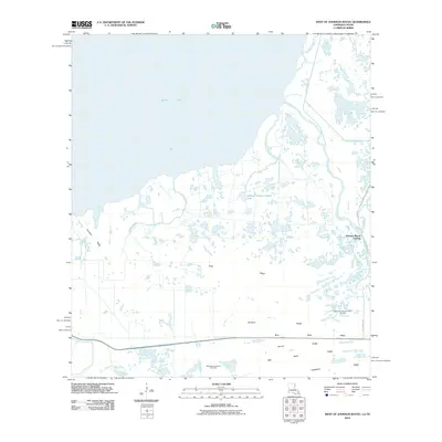
2010 Map of West of Johnson Bayou
USGS Topo · Published 2010About this map
Sabine Lake dominates the upper reaches of this coastal landscape, where the marshy terrain of Louisiana meets the eastern edge of Texas. The topography is defined by a series of subtle elevations known locally as ridges, which likely provided the only dry ground for early inhabitants. These features, including Garrison Ridge, Sanders Ridge, and Buck Ridge, appear as narrow strips of land amidst a complex network of waterways like Greens Bayou and Madame Johnson Bayou. The maritime and industrial character of the region is evident at Johnson Bayou Landing, while the subsurface energy economy is marked by the Northwest Johnson Bayou Gas Field and West Johnson Bayou Gas Field. Further inland, family or descriptive names designate smaller rises such as Garner Ridge and Hackberry Ridge, illustrating the long-standing human connection to this specific coastal geography.
Find a feature on this map
24 named features on this map. Tap any name to fly to it.
Don’t see what you’re looking for? This feature index may not catch every label — zoom into the map to look around manually.
Map Details
Editions of this 2010 West of Johnson Bayou Map
This is the sole edition of this map. No revisions or reprints were ever made.
Other maps of this area

1932 · Sabine Pass NE
USGS Topo · 1:31,680

1932 · Port Arthur NE
USGS Topo · 1:31,680

1934 · Johnsons Bayou
USGS Topo · 1:24,000

1934 · Greens Bayou
USGS Topo · 1:24,000

1935 · Greens Bayou
USGS Topo · 1:31,680

1935 · Johnsons Bayou
USGS Topo · 1:31,680

1943 · West of Johnson Bayou
USGS Topo · 1:24,000

1943 · West of Greens Bayou
USGS Topo · 1:24,000

1943 · Port Arthur North
USGS Topo · 1:24,000

1943 · Port Arthur South
USGS Topo · 1:24,000