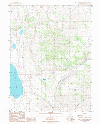
1989 Map of West of Snowstorm Mtn
USGS Topo · Published 1989About this map
Snowstorm Mountain dominates the eastern high ground of this Lassen County landscape, descending toward the expansive basin of Horse Lake to the west. This late-twentieth-century survey documents a high-desert environment defined by its water sources, including the protected Snowstorm Wetland and the perennial flow of Snowstorm Creek. At the base of the mountain's northern slopes sits the Snowstorm Ranch, illustrating the area's continued use for livestock and land management. The presence of the White Horse Spring and the drainage of Petes Creek further highlight the critical role of hydration points in this arid region. Several instances of Rock Walls are mapped across the terrain, serving as durable remnants of early ranching infrastructure and boundary marking in the northeastern California interior.
Find a feature on this map
9 named features on this map. Tap any name to fly to it.
Don’t see what you’re looking for? This feature index may not catch every label — zoom into the map to look around manually.
Map Details
Editions of this 1989 West of Snowstorm Mtn Map
This is the sole edition of this map. No revisions or reprints were ever made.
Other maps of this area

1886 · Honey Lake
USGS Topo · 1:250,000

1891 · Honey Lake
USGS Topo · 1:250,000

1893 · Honey Lake
USGS Topo · 1:250,000

1954 · Karlo
USGS Topo · 1:62,500

1954 · Grasshopper Valley
USGS Topo · 1:62,500

1954 · Ravendale
USGS Topo · 1:62,500

1954 · Fredonyer Peak
USGS Topo · 1:62,500

1955 · Westwood
USGS Topo · 1:250,000

1958 · Westwood
USGS Topo · 1:250,000

1959 · Westwood
USGS Topo · 1:250,000