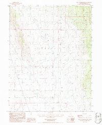
1986 Map of West of Whistler Mtn
USGS Topo · Published 1986About this map
Kobeh Valley dominates this 1980s landscape in central Nevada, providing a clear record of the high-desert topography between the Whistler and Simpson Park Mountains. The terrain is characterized by a high-altitude basin floor dotted with isolated infrastructure, such as the Well located in the northern reaches of the valley. This provisional survey captures the area at a time when land management and grazing were primary drivers of activity, evidenced by the sparse but deliberate placement of water sources. The map's detail on drainage patterns and township boundaries, including the intersection of Township 21 and 22 North, reflects the systematic organization of this expansive public land for ranching and resource use in Eureka County.
Find a feature on this map
5 named features on this map. Tap any name to fly to it.
Don’t see what you’re looking for? This feature index may not catch every label — zoom into the map to look around manually.
Map Details
Editions of this 1986 West of Whistler Mtn Map
This is the sole edition of this map. No revisions or reprints were ever made.
Other maps of this area

1926 · Roberts Mountains
USGS Topo · 1:250,000

1929 · Roberts Mountains
USGS Topo · 1:250,000

1949 · Garden Valley
USGS Topo · 1:62,500

1949 · Roberts Creek Mtn
USGS Topo · 1:62,500

1951 · Roberts Creek Mtn
USGS Topo · 1:62,500

1951 · Garden Valley
USGS Topo · 1:62,500

1955 · Millett
USGS Topo · 1:250,000

1956 · Bartine Ranch
USGS Topo · 1:62,500

1956 · Whistler Mtn
USGS Topo · 1:62,500

1959 · Millett
USGS Topo · 1:250,000