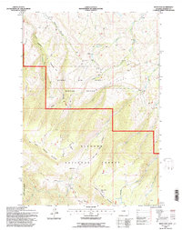
1993 Map of West Pass
USGS Topo · Published 1997About this map
The high country of the Bighorn National Forest dominates this topographic record, reflecting a landscape managed for both livestock and wildlife during the late twentieth century. Dedicated zones like the Kerns Winter Range and the Big Game Range occupy significant portions of the terrain, illustrating the region's importance as a seasonal habitat. The map details the complex drainage systems of the Bighorns, including the branching headwaters of West Pass Creek, Red Gulch, and the Dry Fork.
Find a feature on this map
35 named features on this map. Tap any name to fly to it.
Don’t see what you’re looking for? This feature index may not catch every label — zoom into the map to look around manually.
Map Details
Editions of this 1993 West Pass Map
This is the sole edition of this map. No revisions or reprints were ever made.
Other maps of this area

1894 · Rosebud
USGS Topo · 1:125,000

1894 · St. Xavier
USGS Topo · 1:125,000

1895 · Dayton
USGS Topo · 1:125,000

1898 · Bald Mountain
USGS Topo · 1:125,000

1901 · Rosebud
USGS Topo · 1:125,000

1901 · Dayton
USGS Topo · 1:125,000

1901 · St. Xavier
USGS Topo · 1:125,000

1901 · Bald Mountain
USGS Topo · 1:125,000

1954 · Hardin
USGS Topo · 1:250,000

1955 · Sheridan
USGS Topo · 1:250,000