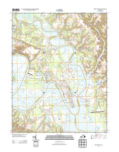
2013 Map of West Point
USGS Topo · Published 2013About this map
The confluence of the Mattaponi River and the Pamunkey River forms the headwaters of the York River at West Point, a strategic tidewater location defined by its peninsula geography. This 2013 survey illustrates the dense residential and industrial grid of West Point and its northern neighbor Port Richmond, connected to the southern shore by the Lord Delaware Bridge and Eltham Bridge. The surrounding landscape is characterized by extensive wetlands and named reaches such as Thorofare and Glass Island, with outlying settlements like Eltham, Mattaponi, and Shanghai dotting the primary road corridors.
Find a feature on this map
61 named features on this map. Tap any name to fly to it.
Don’t see what you’re looking for? This feature index may not catch every label — zoom into the map to look around manually.
Map Details
Editions of this 2013 West Point Map
This is the sole edition of this map. No revisions or reprints were ever made.
Other maps of this area

1906 · Williamsburg
USGS Topo · 1:62,500

1917 · Urbanna
USGS Topo · 1:62,500

1917 · Toano
USGS Topo · 1:62,500

1918 · Toano
USGS Topo · 1:62,500

1919 · New Kent
USGS Topo · 1:62,500

1943 · Richmond
USGS Topo · 1:250,000
1949 · Truhart
USGS Topo · 1:24,000

1949 · Shacklefords
USGS Topo · 1:24,000
1949 · King And Queen
USGS Topo · 1:24,000
1949 · Samos
USGS Topo · 1:24,000