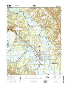
2016 Map of West Point
USGS Topo · Published 2016About this map
The confluence of the Mattaponi River and the Pamunkey River forms the headwaters of the York River at the tip of the peninsula where West Point is situated. This strategic Tidewater location is defined by its extensive marshlands, including Eltham Marsh and Lee Marsh, which dominate the western shoreline. The town's grid is dense with history, featuring local landmarks such as Sunny Slope Cem and Saint Theresas Cem. Transportation infrastructure is a central theme, with the Lord Delaware Bridge and Eltham Bridge providing critical crossings that connect the peninsula to neighboring King and Queen and New Kent counties.
Find a feature on this map
112 named features on this map. Tap any name to fly to it.
Don’t see what you’re looking for? This feature index may not catch every label — zoom into the map to look around manually.
Map Details
Editions of this 2016 West Point Map
This is the sole edition of this map. No revisions or reprints were ever made.
Other maps of this area

1906 · Williamsburg
USGS Topo · 1:62,500

1917 · Urbanna
USGS Topo · 1:62,500

1917 · Toano
USGS Topo · 1:62,500

1918 · Toano
USGS Topo · 1:62,500

1919 · New Kent
USGS Topo · 1:62,500

1943 · Richmond
USGS Topo · 1:250,000
1949 · Truhart
USGS Topo · 1:24,000

1949 · Shacklefords
USGS Topo · 1:24,000
1949 · King And Queen
USGS Topo · 1:24,000
1949 · Samos
USGS Topo · 1:24,000