1973 Map of West Point
USGS Topo · Published 1977About this map
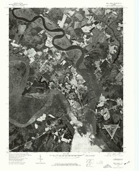
The confluence of two major waterways forms the center of activity on this 1973 orthophoto map, where the Mattaponi River and the Pamunkey River merge to create the broad York River. At this strategic point sits the town of West Point, a settlement whose development is closely tied to the surrounding waters and wetlands. This aerial perspective, captured in April 1973, reveals a landscape defined by sharp contrasts between geometric agricultural fields, dense woodlands, and the organic, winding curves of the river systems. The town itself appears as a concentrated grid of development along the peninsula, with clear industrial and transportation infrastructure visible along its waterfronts. This document provides a direct visual record of Virginia's Tidewater region before later twentieth-century expansions, showing the precise relationship between the historic riverfront and the inland forests.
Find a feature on this map
4 named features on this map. Tap any name to fly to it.
Don’t see what you’re looking for? This feature index may not catch every label — zoom into the map to look around manually.
Map Details
Editions of this 1973 West Point Map
This is the sole edition of this map. No revisions or reprints were ever made.
Other maps of this area

1906 · Williamsburg
USGS Topo · 1:62,500

1917 · Urbanna
USGS Topo · 1:62,500

1917 · Toano
USGS Topo · 1:62,500

1918 · Toano
USGS Topo · 1:62,500

1919 · New Kent
USGS Topo · 1:62,500

1943 · Richmond
USGS Topo · 1:250,000

1949 · Truhart
USGS Topo · 1:24,000

1949 · Shacklefords
USGS Topo · 1:24,000

1949 · King And Queen
USGS Topo · 1:24,000
1949 · Samos
USGS Topo · 1:24,000