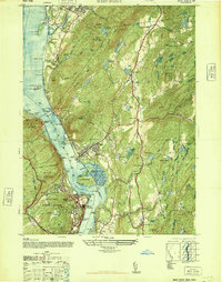
1947 Map of West Point
USGS Topo · Published 1947About this map
The West Point Military Reservation dominates the west bank of the river, showing the academy and surrounding terrain just after the war. This 1947 survey captures a critical transition in the Hudson Highlands, documenting the strategic landscape around Constitution Island and the neighboring civilian hubs. On the eastern shore, the village of Cold Spring and its neighbor Nelsonville are shown in detail, situated across from Storm King Mountain. The presence of the Catskill Aqueduct and numerous reservoirs like Melzingah Reservoir and Cold Spring Reservoir highlights the region's importance to New York's water infrastructure. Local landmarks like Pollepel Island and the New York Central rail line along the river illustrate the industrial and transport history of the corridor, while family-named corners such as Mekeel Corners and Travis Corners offer valuable data for genealogical research into the area's rural settlement patterns.
Find a feature on this map
92 named features on this map. Tap any name to fly to it.
Don’t see what you’re looking for? This feature index may not catch every label — zoom into the map to look around manually.
Map Details
Editions of this 1947 West Point Map
This is the sole edition of this map. No revisions or reprints were ever made.
Other maps of this area

1892 · West Point
USGS Topo · 1:62,500

1893 · Poughkeepsie
USGS Topo · 1:62,500

1894 · West Point
USGS Topo · 1:62,500

1894 · Poughkeepsie
USGS Topo · 1:62,500

1899 · West Point
USGS Topo · 1:62,500

1901 · West Point
USGS Topo · 1:62,500

1902 · Schunemunk
USGS Topo · 1:62,500

1903 · Poughkeepsie
USGS Topo · 1:62,500

1903 · Newburg
USGS Topo · 1:62,500

1930 · Schunemunk
USGS Topo · 1:48,000