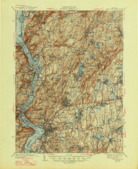
1947 Map of West Point
USGS Topo · Published 1947About this map
The Hudson River serves as the central artery for this 1930s-era study, framing a landscape defined by industrial transit and strategic geography. On the western bank, the West Point Military Reservation and Bear Mountain anchor the highlands, while the New York Central RR tracks line the eastern shore, connecting riverfront settlements like Cold Spring and Beacon. This period shows the emergence of the Taconic State Parkway winding through the interior, signaling a shift toward modern automobile travel through the hills of Philipstown and Putnam Valley.
Find a feature on this map
214 named features on this map. Tap any name to fly to it.
Don’t see what you’re looking for? This feature index may not catch every label — zoom into the map to look around manually.
Map Details
Editions of this 1947 West Point Map
This is the sole edition of this map. No revisions or reprints were ever made.
Other maps of this area

1891 · Ramapo
USGS Topo · 1:62,500

1892 · Stamford
USGS Topo · 1:62,500

1892 · West Point
USGS Topo · 1:62,500

1892 · Carmel
USGS Topo · 1:62,500

1892 · Tarrytown
USGS Topo · 1:62,500

1893 · Carmel
USGS Topo · 1:62,500

1893 · Stamford
USGS Topo · 1:62,500

1893 · Tarrytown
USGS Topo · 1:62,500

1893 · Ramapo
USGS Topo · 1:62,500

1893 · Clove
USGS Topo · 1:62,500