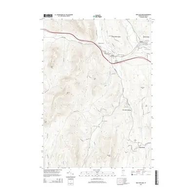
2015 Map of West Rutland
USGS Topo · Published 2015About this map
West Rutland serves as a focal point in this valley landscape where the Castleton River and Clarendon River meet the rising slopes of Herrick Mtn and Bird Mtn. The 2015 layout reveals a dense network of local cemeteries, including Saint Bridgets Cem, Saint Stanislaus Kostka Cem, and Sacred Heart Cem, reflecting the deep social and religious history of the surrounding communities. This concentration of sites, paired with the Coll of St Joseph in Center Rutland, highlights the area's development as a hub of education and faith nestled between the Taconic and Green Mountain ranges.
Find a feature on this map
83 named features on this map. Tap any name to fly to it.
Don’t see what you’re looking for? This feature index may not catch every label — zoom into the map to look around manually.
Map Details
Editions of this 2015 West Rutland Map
This is the sole edition of this map. No revisions or reprints were ever made.
Other maps of this area

1891 · Rutland
USGS Topo · 1:62,500

1893 · Wallingford
USGS Topo · 1:62,500

1893 · Rutland
USGS Topo · 1:62,500

1894 · Pawlet
USGS Topo · 1:62,500

1895 · Castleton
USGS Topo · 1:62,500

1897 · Pawlet
USGS Topo · 1:62,500

1897 · Castleton
USGS Topo · 1:62,500

1903 · Mettawee
USGS Topo · 1:125,000

1944 · Proctor
USGS Topo · 1:31,680
1944 · Bomoseen
USGS Topo · 1:31,680