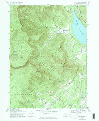
1969 Map of West Shokan
USGS Topo · Published 1971About this map
Ashokan Reservoir dominates the eastern landscape of this Catskills region, providing a stark contrast to the dense mountain terrain of the Catskill State Park. The map documents a rugged interior defined by high peaks such as High Point (Samson) and Friday Mtn, while small settlements like West Shokan and Samsonville anchor the local valleys. A detailed network of roads and trails, including the Peekamoose Trail, reveals the area's transition from an industrial past to a protected recreational landscape. Local history is preserved through the locations of the Palentown Cem and an isolated Mine in Maltby Hollow. The presence of the Penn Central rail line near the reservoir's edge highlights the historical transportation corridor that once served these mountain communities before the mid-century shifts in regional infrastructure.
Find a feature on this map
62 named features on this map. Tap any name to fly to it.
Don’t see what you’re looking for? This feature index may not catch every label — zoom into the map to look around manually.
Map Details
Editions of this 1969 West Shokan Map
3 editions found
Other maps of this area

1892 · Kaaterskill
USGS Topo · 1:62,500

1893 · Kaaterskill
USGS Topo · 1:62,500

1894 · Kaaterskill
USGS Topo · 1:62,500

1899 · Kaaterskill
USGS Topo · 1:62,500

1900 · Phoenicia
USGS Topo · 1:62,500

1901 · Rosendale
USGS Topo · 1:62,500

1903 · Rosendale
USGS Topo · 1:62,500

1903 · Phoenicia
USGS Topo · 1:62,500

1903 · Kaaterskill
USGS Topo · 1:62,500

1903 · Slide Mountain
USGS Topo · 1:62,500