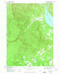
1969 Map of West Shokan
USGS Topo · Published 1975About this map
Ashokan Reservoir dominates the northeastern corner of this 1969 survey, where the Penn Central rail line skirted the shore near West Shokan. The landscape is a study in the intersection of public land and rural settlement, with the vast Catskill State Park and various sections of the State Forest Preserve blanketing the high peaks. Deep valleys such as Maltby Hollow Brook and Bush Kill provided the primary corridors for early access, while peaks like Friday Mtn and Mombaccus Mtn defined the township boundaries between Shandaken, Rochester, and Olive. For local historians, the map preserves the locations of smaller 19th-century hamlets like Samsonville and Palentown, the latter of which includes the Palentown Cem. The transition from the high forest preserve to the lower agricultural and residential lands near Beaver Lake is traced through an intricate network of local roads such as Sahler Mill Road and Whispell Road.
Find a feature on this map
63 named features on this map. Tap any name to fly to it.
Don’t see what you’re looking for? This feature index may not catch every label — zoom into the map to look around manually.
Map Details
Editions of this 1969 West Shokan Map
3 editions found
Other maps of this area

1892 · Kaaterskill
USGS Topo · 1:62,500

1893 · Kaaterskill
USGS Topo · 1:62,500

1894 · Kaaterskill
USGS Topo · 1:62,500

1899 · Kaaterskill
USGS Topo · 1:62,500

1900 · Phoenicia
USGS Topo · 1:62,500

1901 · Rosendale
USGS Topo · 1:62,500

1903 · Rosendale
USGS Topo · 1:62,500

1903 · Phoenicia
USGS Topo · 1:62,500

1903 · Kaaterskill
USGS Topo · 1:62,500

1903 · Slide Mountain
USGS Topo · 1:62,500