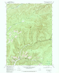
1969 Map of Peekamoose Mtn
USGS Topo · Published 1989About this map
The rugged headwaters of the Catskills define this topographic study, where the West Branch Neversink River and East Branch Neversink River carve deep valleys through the Catskill Park. Small settlements like Sundown and Denning serve as anchor points in a landscape dominated by towering peaks, including Slide Mtn, the highest in the range. The map reveals the intricate drainage network of the region, from the steep descent of Buttermilk Falls Brook to the quiet waters of Peekamoose Lake along Rondout Creek.
Find a feature on this map
43 named features on this map. Tap any name to fly to it.
Don’t see what you’re looking for? This feature index may not catch every label — zoom into the map to look around manually.
Map Details
Editions of this 1969 Peekamoose Mtn Map
2 editions found
Other maps of this area

1900 · Phoenicia
USGS Topo · 1:62,500

1901 · Margaretville
USGS Topo · 1:62,500

1903 · Phoenicia
USGS Topo · 1:62,500

1903 · Slide Mountain
USGS Topo · 1:62,500

1904 · Margaretville
USGS Topo · 1:62,500

1905 · Slide Mountain
USGS Topo · 1:62,500

1910 · Neversink
USGS Topo · 1:62,500

1942 · West Shokan
USGS Topo · 1:24,000

1942 · Neversink
USGS Topo · 1:62,500

1942 · Lackawack
USGS Topo · 1:24,000