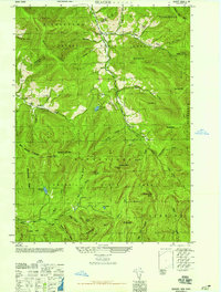
1946 Map of Seager
USGS Topo · Published 1946About this map
Catskill State Park encompasses this high-elevation landscape in the mid-1940s, a region defined by steep ridges and narrow hollows. Small mountain settlements like Mapledale and Seager sit along the winding path of Dry Brook, where the terrain briefly levels enough to support local habitation. The infrastructure of the era is preserved through markers like School No 4 and the Lake Hill Cem, indicating the scattered but established communities tucked into the valleys between Belle Ayr Mtn and Haynes Mtn.
Find a feature on this map
49 named features on this map. Tap any name to fly to it.
Don’t see what you’re looking for? This feature index may not catch every label — zoom into the map to look around manually.
Map Details
Editions of this 1946 Seager Map
This is the sole edition of this map. No revisions or reprints were ever made.
Other maps of this area

1900 · Phoenicia
USGS Topo · 1:62,500

1901 · Margaretville
USGS Topo · 1:62,500

1903 · Phoenicia
USGS Topo · 1:62,500

1903 · Slide Mountain
USGS Topo · 1:62,500

1904 · Margaretville
USGS Topo · 1:62,500

1905 · Slide Mountain
USGS Topo · 1:62,500

1910 · Neversink
USGS Topo · 1:62,500

1942 · Neversink
USGS Topo · 1:62,500

1943 · Peekamoose Mountain
USGS Topo · 1:31,680

1943 · Monticello
USGS Topo · 1:125,000