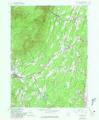
1945 Map of Woodstock
USGS Topo · Published 1981About this map
Catskill Park dominates the northwest corner of this quadrangle, where the steep elevations of Overlook Mountain and Plattekill Mountain rise above the surrounding valleys. This mid-century survey, updated with late-1970s aerial revisions, illustrates the hydrologic infrastructure supporting nearby populations, specifically the Saugerties Reservoir and a tiered system including Kingston Reservoir No 2, Kingston Reservoir No 1, and Kingston Reservoir No 4.
Find a feature on this map
46 named features on this map. Tap any name to fly to it.
Don’t see what you’re looking for? This feature index may not catch every label — zoom into the map to look around manually.
Map Details
Editions of this 1945 Woodstock Map
4 editions found
Other maps of this area

1892 · Kaaterskill
USGS Topo · 1:62,500

1893 · Kaaterskill
USGS Topo · 1:62,500

1894 · Kaaterskill
USGS Topo · 1:62,500

1895 · Catskill
USGS Topo · 1:62,500

1898 · Rhinebeck
USGS Topo · 1:62,500

1899 · Kaaterskill
USGS Topo · 1:62,500

1901 · Rosendale
USGS Topo · 1:62,500

1903 · Rosendale
USGS Topo · 1:62,500

1903 · Kaaterskill
USGS Topo · 1:62,500

1934 · Rhinebeck
USGS Topo · 1:48,000