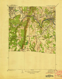
1938 Map of West Springfield
USGS Topo · Published 1938About this map
Westfield and West Springfield define the northern half of this late-1930s landscape, where industrial infrastructure meets rural expansion across the Westfield River. The map illustrates a transitional period of public works and social institutions, marked by the extensive aqueduct system and the presence of the Westfield State Sanatorium near the base of West Mountain. In the south, the village of Agawam and its surrounding hamlets like Feeding Hills and North Agawam show a dense network of local roads such as Hartford Street and New Haven Street. The central vertical ridge of Proven Mountain creates a natural divide, shielding the smaller settlements of Hosmer Corner and Johnson Corner from the more developed river valley. Genealogists will find value in the specific placement of the Hampden County Training Sch and historic landmarks like the Monastery and St James Ch.
Find a feature on this map
76 named features on this map. Tap any name to fly to it.
Don’t see what you’re looking for? This feature index may not catch every label — zoom into the map to look around manually.
Map Details
Editions of this 1938 West Springfield Map
3 editions found
Other maps of this area

1886 · Springfield
USGS Topo · 1:62,500

1887 · Granville
USGS Topo · 1:62,500

1889 · Springfield
USGS Topo · 1:62,500

1889 · Granville
USGS Topo · 1:62,500

1892 · Hartford
USGS Topo · 1:62,500

1892 · Granby
USGS Topo · 1:62,500

1893 · Springfield
USGS Topo · 1:62,500

1893 · Granville
USGS Topo · 1:62,500

1895 · Springfield
USGS Topo · 1:62,500

1895 · Granville
USGS Topo · 1:62,500